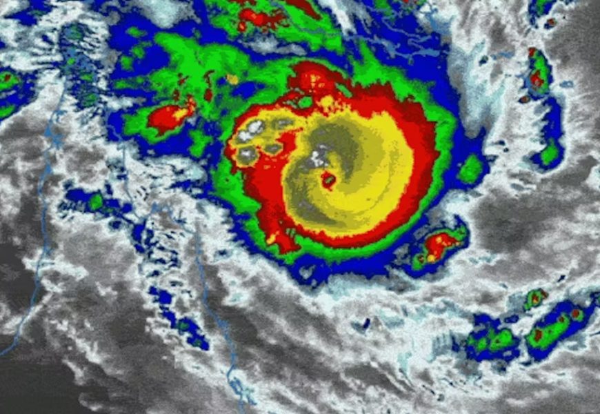
Tropical Cyclone Narelle is currently a very dangerous Category 5 storm, sitting off the Far North Queensland Coast some 350 kilometres northeast of Cooktown. Formed in the Coral Sea, Narelle is packing a punch, with sustained winds near the centre of 205km per hour and wind gusts to 285km per hour.
Cyclone Narelle: 'compact', dangerous and unusually predictable
Tropical Cyclone Narelle is currently a very dangerous Category 5 storm, sitting off the Far North Queensland Coast some 350 kilometres northeast of Cooktown. Formed in the Coral Sea, Narelle is packing a punch, with sustained winds near the centre of 205km per hour and wind gusts to 285km per hour.
Sea surface temperatures in the northwest Coral Sea are currently 0.5-1.0°C above average, and this has fuelled the storm's rapid intensification.
The cyclone's centre is barrelling towards Cape York at a rapid 26km per hour, and predicted to cross the coast between the Aboriginal community of Lockhart River and Cape Melville on Friday morning. It is expected to weaken a little before it hits land and arrive as a still-dangerous Category 4 cyclone. The small inland town of Coen is also in its path.
The intensity and path of cyclones that form in the Coral Sea are usually difficult to predict. This is because they are pushed in different directions by highly changeable winds, unlike cyclones in most other tropical ocean basins.
Yet Cyclone Narelle has followed a predictable westward path, which makes this cyclone highly unusual.
Where will it go?
The Bureau of Meterology warns that tides in Princess Charlotte Bay, at the base of the narrow part of Cape York Peninsula, are likely to rise significantly above the normal high tide, with dangerous ocean flooding. Any coastal residents in this area are warned of a possible dangerous storm tide as the cyclone centre crosses the coast.
In March 1899, Cyclone Mahina hit the same general area. Cyclone Mahina is considered the deadliest tropical cyclone in Australia's recorded history, and probably one of the most intense ever recorded globally.
After crossing eastern Cape York, Narelle will weaken rapidly to Category 2 status, before emerging over the warm waters of the Gulf of Carpentaria during the early hours of Saturday morning. Narelle is expected to intensify again as the cyclone heads steadily towards the eastern Northern Territory.
After crossing the NT as a deep tropical low, Narelle is expected to reintensify off the Kimberley coast during next week before shifting into the Indian Ocean. Fortunately, its quick-moving speed means it won't have the time to dump lots of rain over swollen catchments across the Top End. Nonetheless, river rises are forecast as the centre moves through.

A strong and 'compact' cyclone
Narelle is a very compact cyclone, meaning it has a relatively small area of intense winds around its centre. The area of these destructive hurricane-force winds only extends 50km from its centre, while destructive storm force and damaging gale-force winds extend 75km and 130km, respectively.
Due to the laws of physics, smaller cyclones typically spin up faster than larger ones. Likewise, they also weaken rapidly after moving over land areas. Larger cyclones have more inertia, taking longer to spin up over warm oceans and to wind down over land masses.
When it comes to cyclone size (as measured by the area of outer strong gales), there's no room for complacency. Australia's most infamous cyclone - Tracy in December 1974 - only had gales extending 40-50km from the eye. But the extreme core winds hit Darwin directly. Because of this, 70-90% of the city's buildings were damaged, 60-80% of houses were totally destroyed, and roughly 94% of all housing in the city was rendered uninhabitable. The official death toll was 66 people, with more than 145 severely injured.
As Narelle threatens communities on the Cape York Peninsula, we are reminded of another severe weather event with similar characteristics that also hit northeast Queensland.
Exactly 20 years ago, Severe Tropical Cyclone Larry struck Innisfail, 90km south of Cairns, as an intense Category 4 storm. Larry caused significant damage to Innisfail and neighbouring towns, but largely spared Cairns city. Larry caused widespread structural damage, but also wiped out most of Australia's banana crop, leading to record high prices.
Cyclone Larry was one of very few Coral Sea cyclones that followed a predictable westward track towards the coast. Not only was its track predictable, but also how quickly it moved forward and its intensity at landfall. Such agreement among forecasting weather models is rare for the Coral Sea, that is globally recognised for its erratic cyclone behaviour.
Coral Sea cyclones
So, what makes Cyclones Larry and Narelle unusual for the Coral Sea?
To answer this question, we need to understand how winds behave around tropical cyclones. Cyclones are affected by winds at different heights in the atmosphere. These can cause them to stall if equally opposing winds meet in the region around the cyclone. In other cases, dominant winds from a particular directions will push them along on a clear path. These are called steering winds.
Cyclones are largely steered by winds in the mid levels of the troposphere - roughly 3-7km above the surface. Severe cyclones - like Narelle - are propelled along by winds at the higher end of this range, due to their deep vertical structures, meaning they are taller. Weaker cyclones have a much shallower depth in the atmosphere, so the dominant steering winds are much lower down.
In the case of Narelle (and Larry), a persistent, deep subtropical ridge of high pressure over eastern Australia and the Coral Sea is acting like a conveyor belt, directing the steering winds around the cyclone centre from east to west. This pattern is predicted to continue into next week, which will eventually push Narelle into the Indian Ocean.
There's another attribute of fast-moving cyclones that is relevant here. In the Southern Hemisphere, all cyclones rotate clockwise due to the Coriolis Force. Narelle's fast-forward speed means areas south of the eye of the cyclone will experience more severe onshore storm conditions.
TheConversation.com
Author: Steve Turton - Adjunct Professor of Environmental Geography, CQUniversity Australia
https://theconversation.com/cyclone-narelle-compact-dangerous-and-unusually-predictable-278767
More Top Stories