Warm water and air and unusual weather conditions tracing back as far as tropical cyclone flooding in Indonesia helped supercharge stubborn atmospheric rivers that have drenched Washington state with almost 5 trillion gallons (19 trillion liters) of rain in the past seven days, threatening record flood levels, meteorologists said.
Blend of unusual weather conditions brings trillions of gallons in persistent rain to the Northwest
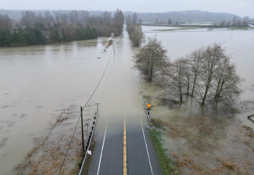

Warm water and air and unusual weather conditions tracing back as far as tropical cyclone flooding in Indonesia helped supercharge stubborn atmospheric rivers that have drenched Washington state with almost 5 trillion gallons (19 trillion liters) of rain in the past seven days, threatening record flood levels, meteorologists said.
The worst and most persistent of the heavy rains will linger to douse the same location through late Thursday and early Friday morning before the river of moisture should lessen and move around a bit. But the West Coast likely won’t see an end to the “fire hose” of moisture until the week of Christmas, said Matt Jeglum, acting science chief for the National Weather Service’s western region.
Atmospheric rivers are long, narrow bands of water vapor that form over an ocean and flow through the sky, transporting moisture from the tropics to northern latitudes. The Pacific Northwest gets a couple dozen each year, more than other parts of the West Coast, meteorologists said. But they’re not usually this big.
Wednesday’s downpours coupled with Monday’s rains have led to forecasts of record-setting flooding, particularly on the Skagit River, which flows through northern Washington and empties into the Puget Sound, said Washington state climatologist Guillaume Mauger.