Queensland is once again on flood alert as already swollen rivers and saturated catchments face the prospect of renewed heavy rainfall, particularly across the state's north. A flood watch remains in force for large parts of Queensland, with forecasters warning that a slow-moving weather system could deliver significant rain over several consecutive days.
Queensland on Flood Alert as Slow-Moving Trough Threatens Days of Heavy Rain
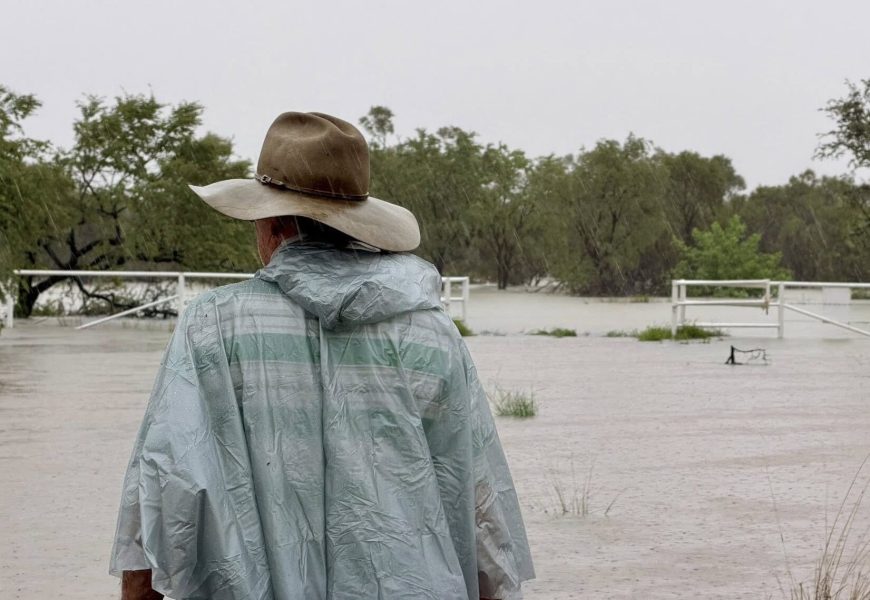
Queensland is once again on flood alert as already swollen rivers and saturated catchments face the prospect of renewed heavy rainfall, particularly across the state's north. A flood watch remains in force for large parts of Queensland, with forecasters warning that a slow-moving weather system could deliver significant rain over several consecutive days.
The Bureau of Meteorology says a broad trough is expected to migrate north and linger, increasing the risk of widespread showers, thunderstorms and potentially dangerous rainfall totals. With waterways already elevated after recent wet weather, even moderate additional falls could lead to rapid river rises and localised flooding.
Rainfall totals recorded since the weekend highlight the scale of the system already impacting the state. Parts of north Queensland received more than 100 millimetres in just 24 hours from Sunday morning, with 183 millimetres falling at Japoonvale, south-west of Innisfail, and 167 millimetres recorded at Rollingstone near Townsville. Further south, Coops Corner near Noosa was the wettest location in south-east Queensland, recording 106 millimetres in a single day.
Looking ahead, forecasters say the wet conditions are far from over. Clear skies are expected to be scarce across much of Queensland before the weekend, with some centres facing the potential for very high weekly totals. Mackay is forecast to receive up to 270 millimetres across the week, while Townsville could see around 190 millimetres. Cairns is expected to receive up to 115 millimetres, with Innisfail tipped to collect as much as 140 millimetres.
The weather bureau has warned that flooding is possible across parts of southern, central and northern Queensland in the coming days, particularly where repeated downpours fall over the same catchments. Senior forecaster Lauren Sharpe said river levels could rise quickly in areas that receive the heaviest rain, though she stressed there remains uncertainty around exactly where the most intense falls will occur.
"There's no fixed focus for any particular part of north Queensland at this stage," Ms Sharpe said. "It's more a broad risk across the north, driven by the slow movement of the trough and ongoing moisture in the atmosphere."
In addition to the flood watch, severe thunderstorm warnings have been issued for central and northern districts, with slow-moving storms posing a heightened risk of heavy rainfall and flash flooding. Areas under warning include the North Tropical Coast and Tablelands, Northern Goldfields and Upper Flinders, Herbert and Lower Burdekin, as well as the North West and Central West districts.
While the rain dominates forecasts in the north, much of Queensland is also experiencing an unseasonably cool spell. Following a wet weekend, temperatures across large parts of the state dropped to as much as 12 degrees below the February average on Sunday. The Bureau says extensive cloud cover combined with persistent cold winds has driven the cooler conditions.
Ms Sharpe said Sunday was expected to be the coldest day for many locations, but cooler-than-average temperatures would linger through the south-east and southern interior for several more days. "Temperatures will gradually recover in the far south from the middle of the week," she said. "Across the rest of the week, we expect maximum temperatures to return close to average, and even slightly above average through the Granite Belt on Thursday. Importantly, there's no sign of a heatwave over the next week."
Authorities are urging residents in flood-prone areas to stay informed, monitor weather warnings and river levels closely, and prepare for rapidly changing conditions as the week unfolds.
More Top Stories